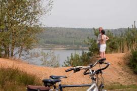
In addition to the extensive hiking trail network and the well-known cycling route network, the National Park now also boasts a mountain bike network!
The network includes 160K of mountain-bike tracks, spread over six loops. Both the novice and the advanced biker will find something to their liking here. The precipitous edge, which was created by the transition between the Meuse valley and the Kempisch plateau, makes for the often steep climbs and descents, with height differences of up to 45 meters.
For mountain bikers who like even tougher challenges, there is the bike marathon: an 80K trip that is marked out with black arrows between Maaseik and Lanaken.
That way, the range on offer in Limburg for mountain bikers is ever more appealing. This is on top of the already existing Central Limburg Mountain Biking Network (136 km of marked routes), along with the linked Euregio Mountain Biking Network (682 km), the Western Limburg Mountain Biking Network (100 km), the Northern Limburg Mountain Biking Network (270 km) and the first phase of the Hoge Kempen Network (45 km) in the 'Duinengordel’. More specific information about the Limburg mountain bike networks can be found here: www.limburg.be/mountainbikenetwerken. We even gave some thought to the 'modern' mountain bikers, who use their GPS on their trips. That's why the GPS tracks are also available on this site.
This network is also a fine example of cooperation. In order to create the 160 kilometres of routes, the province of Limburg invited various parties (including the Agency for Nature and Forests and Regionaal Landschap Kempen en Maasland), organisations (mountain bike clubs, starting place operators, etc.) and the towns involved (Maaseik, Dilsen-Stokkem, Maasmechelen, Lanaken, Zutendaal, Genk and As) around the table.